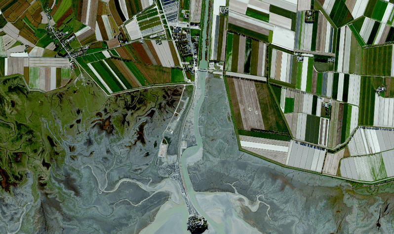
Satellite images for vivid environmental stories
by Dan Hammer, 2017 Pritzker Emerging Environmental Genius Award finalist
I don’t know what to trust in the news anymore. I have taken to reading The Onion for hard-hitting investigative journalism. This is an especially troubling proposition for environmentalism. Any efficient or equitable allocation of natural resources depends crucially on open and trustworthy information on the environment. Any collective action for conservation relies on independent environmental reporting. The objective of our project, called Overview News, is to enhance environmental reporting with satellite imagery — a low-cost source of independent, credible, and globally consistent information about the Earth.
Satellite imagery will be the basis for a tectonic shift in environmental reporting — not just improvements on the margin, but a truly disruptive impact. This new medium can effectively and reliably report on changes to the natural landscape. There is nothing more unbiased than the flyby images from a small piece of metal in low Earth orbit traveling at ten thousand miles per hour.
To date, however, satellite imagery has been largely reserved for use by the defense and intelligence industry. This is changing. The technology stack to build, launch, and maintain a flock of satellites is becoming increasingly affordable. There are now over 67 non-military providers of optical imagery across 34 countries, according to the United Nations Office for Outer Space Affairs. The proliferation and commodification of Earth imagery has created the opportunity to use the data for broader social and environmental applications.

My team and I are working with dozens of journalists who already use satellite imagery to validate and enhance their news stories. Still, this existing demand could be greatly expanded. Our research suggests that over 250 stories each day could be materially enhanced with satellite imagery, but are not due to the excessively high transaction costs of dealing with the data. It takes an undue amount of effort to use the images for non-military applications. The industry was not built to service a broad base of non-governmental users. Our team is building the basic digital infrastructure to enable a broader use of the imagery. Specifically, we are writing the security, licensing, and web service layers to democratize access to satellite imagery — starting with environmental journalists.
One feature that is especially important to journalists is the search and discovery layer. If you had all the imagery in the world, where would you look? We employ a mix of natural language processing, computer vision, and crowd-sourced curation to identify relevant stories and their images. The objective of this layer is to connect local knowledge to overhead imagery. While the imagery can validate and illustrate events, it takes people to tell stories and interpret the change. Part of our offering is a sort of newswire from satellite imagery, which news outlets use to seed their own stories. Content from the wire is repurposed and republished by news outlets, lowering the functional cost of using the imagery.
Our technology has already been used by a few major news outlets, including Reuters and affiliates of the Pulitzer Center for Crisis Reporting. We have reported on illegal deforestation in Peru, refugee encampments in Jordan, and slum destruction in Nigeria. There are thousands of other stories that can benefit from an overhead view. We may not all agree on the interpretation of the images, but we can at least agree on the way the world is represented in the images. At least I hope so.
Units
Topics
MEET THE AUTHOR