In this research, species distribution modeling is used as a tool to understand the environmental determinants that control the distribution of species and to obtain spatial patterns on the species’ distribution. Current projects include evaluating the usefulness of newly available vegetation remote sensing data (e.g., from NASA’s Moderate Imaging Spectroradiometer [MODIS]) in species distributional modeling, understanding the spatial distribution of tree diversity in the Amazon basin, predicting present-day, future, and past distribution of biomes and vertebrates in the diverse Tropical Andes, predicting invasions of savanna reptiles into fragmented rainforests in Cameroon, and modeling the geographic distribution of avian malaria blood parasites throughout African rainforests. In species distributional modeling, also called “bioclimatic envelope modeling,” empirical relationships between observed species distributions and environmental variables are established and, thereafter, projected onto geographic space.
A relatively new research venue involves explaining and predicting genetic and morphological diversity over a landscape using environmental correlates. Species distribution modeling is used as a first step, and statistical relationships between phylogeographic and environmental patterns are determined and projected over the regions where the species of interest is predicted to reside. The results from this project will not only increase our fundamental understanding of evolutionary processes in a spatial context but will also enable decision makers to use this information in developing conservation strategies.
Many of these projects are carried out with NASA-funded grants to the Center for Tropical Research and in collaboration with scientists from NASA’s Jet Propulsion Laboratory.
Some examples of these projects are given below.
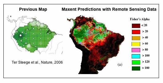
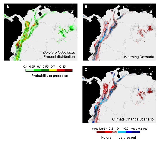
Figure 2: Impact of climate change on the geographic distribution of hummingbirds in the Northern Andes. Panel A: Present potential geographic distribution of the green-fronted lancebill (Doryfera ludoviceae) based on sample locations, observed climate data, and generated through the use of the Maxent algorithm. Panel B: Change map of future minus present-day distribution. The present-day climate-species relationship was projected only on the future temperature change, obtained from a climate model (CCM3) under a double CO2 scenario. Panel C: Similar to Panel B, but in this case the present-day relationship was projected on the total climate change (including changes in precipitation). The change panels document the general tendency of a distributional shift of the hummingbird habitat towards higher elevations as a response to warming.
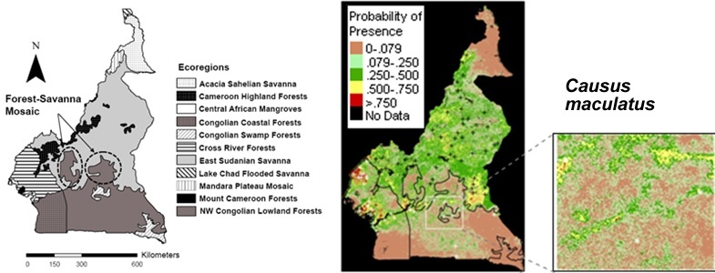
Figure 3: Predicting savanna snake invasion in Cameroon’s rainforest zone. Left panel: Map of ecoregions in Cameroon. Right panel: Potential geographic distribution of the night adder (Causus maculatus), produced through the Maxent algorithm, observed sample locations, and climate and remote sensing data. Predictions of invasion areas in the rainforest zone along major roadways and near urban centers (see inset) are consistent with our hypothesis that human removal of rainforest vegetation facilitates invasion through creation of savanna-like microhabitats.
Related Publications